
Forestry Studies
Establishing a Study Plot
The following forest studies are roughly based on comprehensive studies of a forest outlined by Dan Farr (Forest ecologist with the Hinton Environment School) and the Alberta Prescribed Manual.
If we wanted to find out how many trees there are in a forest or how many needles are on a pine, there would be so many we couldn’t count them all. When we have very large numbers, we count samples then estimate the total amount from a number of smaller counts. We need to be sure when we sample that the samples we take represent the entire population. We use a combination of three methods of sampling in forestry studies:
- Transect Sample: Set out a line and count the items that the line crosses or are next to the line. This is called transect sampling. The greater the number of samples, the more likely that the count is accurate.
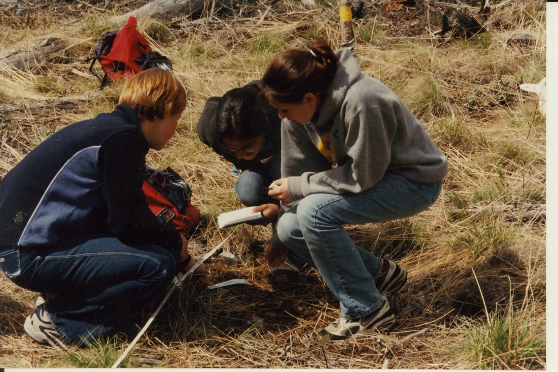
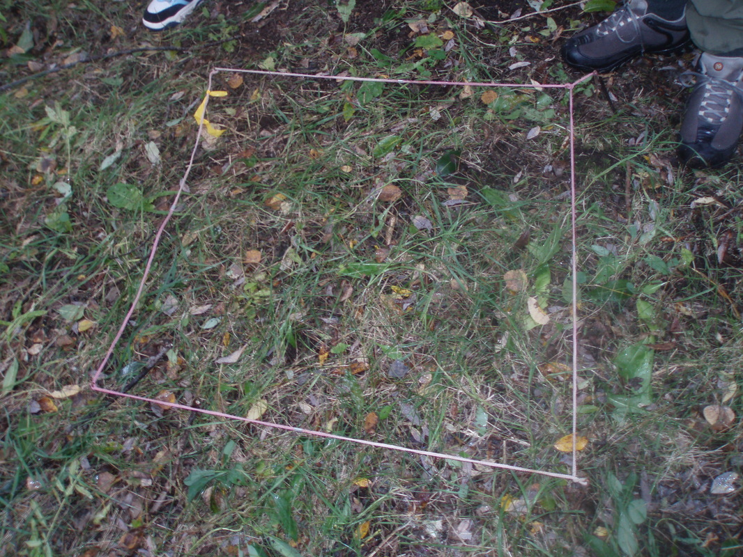
- Area Sample: Set out an area (such as a square 1 meter on all sides) and count the items that fall within the square. This is called quadrant sampling. This type of sampling is used when studying things that grow on the forest floor.
- Volume Sample: Counting the number of organisms in a liter or cubic meter of soil or water is a volume sample. The greater the volume sampled, the more reliable the estimates for the population your are trying to count.
|
|
These studies are based on conducting a number of studies along transects distributed along a 100 meter baseline. This baseline should be set out in an east to west orientation, running through a uniform sample of surrounding forest. The study plots run perpendicular to the base line.The five transect lines are then set out perpendicular to the base line, one each at 10 m, 30 m, 50 m, 70 m and 90 m along the base line. The study area is defined as 5 meters either side of the transect line. The transect line is useful for canopy closure studies, coarse and fine woody debris studies, ground cover plots and for soil pit studies. All trees within 5 meters of either side of the transect line are included in the study area.
Field Notes for Recording Study Observations can be found on this site by clicking here:
These pages are designed to fit into field journals 5.5 by 8.5 inches in size.
Field Notes for Recording Study Observations can be found on this site by clicking here:
These pages are designed to fit into field journals 5.5 by 8.5 inches in size.
|
Site Classification
The Modified UNESCO Classification ( MUC) is a global land cover classification system that follows international standards and ecological terminology for the identification of specific land cover types. The MUC guide is designed to lead you through a series of questions about the environment you are in from the most general (level 1) to the most detailed. Your response to a question (usually either YES or NO) will direct you to the next question until you finally reach the most specific MUC level for your site. Every class within each level has a unique identifier or numerical code. Record this number and compare your classification with those of other groups. Aim to arrive at a common number for your site. Canopy Closure Canopy Closure Canopy Closure: Run 100 m transect from a set waypoint at a given azimuth. You may run parallel transects at waypoints that are offset from the first but along the same azimuth. Two students, one as observer, the other as recorder, walk the transect. The observer uses a hand-held densiometer and tells the recorder if there is vegetation (i.e. branches, leaves, needles) at the crosshairs of the densiometer or not. Take a reading at each meter along the transect. (See UK or GLOBE manual). Determine if canopy cover is open or closed by assessing results using densiometer data forms. Coarse Woody Debris Trees that fall and decay in the forest add nutrients and retain moisture. Fallen trees are referred to as coarse woody debris. The time coarse woody litter takes to decompose is dependent upon moisture and temperature. A fallen log touching the ground will retain moisture and decay more rapidly than one that is suspended above the ground. A sample of course woody material is taken along a transect. Each log greater than 7 cm diameter that is crossed by the transect line is counted. The diameter of the log, distance it is from the ground (height), the state of decay and the amount of bark still on the log are recorded for each log that crosses the transect line. The state of decay is indicated by a scale of decomposition of the wood, the amount of bark left on the log and the % to which the log is covered by moss. Record the results on the data sheets for forestry studies. Ground Cover Ground cover is made up of shorter plants or fungi that grow close to the ground. The amount of ground cover depends on the type of forest it grows in. An open forest lets in more light and usually has more ground cover. A dense forest has a thick canopy with less light reaching the forest floor for ground cover to grow. Ground cover could include young trees, shrubs, ferns, wildflowers, weeds, mosses, and even mushrooms and other fungi. Ground cover is essential to many types of wildlife Ground cover surveys identify the plants that occupy the forest floor. Four 1 meter square quadrant plots are taken to establish a representative sample of plants, debris and bare ground found throughout your forest plot. Estimates of percentage of cover for each plant species, fungi, litter or bare ground are given for the one meter square plot. |
Site Details
Many factors may affect your plot. Where you are (location), the slope of your plot, the aspect (the direction the slope faces), the elevation, the history of disturbances, soil types and climatic changes are all factors affecting the type of forest you are in. Each of these should be measured and recorded at the start of your forestry studies. Location (UTM) Slope in degrees Aspect in azimuth Elevation in M Disturbance history (human or fire history) Climatic changes Plot location on baseline Forest Soils Soils in forests are in part responsible for the types of plants that grow and the types of plants that grow play a part in creating soils. Soil development is a process that takes place over thousands of years. Preparing a soil pit within your forestry plot contributes to an understanding of your forest. More detailed descriptions of how to conduct a soil analysis are given under the soil sampling process. Fine Woody Debris Fine woody debris represents the stage in which nutrients taken in by trees are being recombined with nutriments in the soil. Fine woody material dries quickly. Therefore it decays slowly. Fine woody debris may act as a tinder that promotes the start and spreading of forest fires. Sampling the extent of fine woody debris indicates fire risk and gives clues about the rate of forest decay. Sampling fine woody debris counts and categorizes by sizes, smaller (<7cm) twigs and woody material that has not yet been covered by moss or has not been covered by other plants of the forest floor. Each piece of fine woody debris crossed by the 20 meter plot center line is measured. The fine woody debris are measured in categories; less than .5 cm, .5 to 1 cm, 1 to 3 cm, 3 to 5 cm and 5 to 7 cm. Use a “go - no go” gauge to determine which size category the piece falls into. Record the counts in each category as you move along the line. Wildlife Trees Standing dead or dying trees play an important role in wildlife ecology. These are refered to as `Wildlife Trees` in recognition of their enormous value to birds and other creatures. Many of these dead trees may remain standing for many decades. The primary "colonizers" of snags are insects and fungi. These are essential to all the other wildlife species that depend on or make use of cavities in Wildlife Trees. The variety of invertebrates inhabiting dead and dying trees is staggering. Such species help accelerate the long process of decomposition. By softening the wood, they make it easier for birds and mammals to gain access. Insects also attract woodpeckers and other forest-dwelling animals who, in their search for food, excavate holes or cavities which become nesting sites for other birds and small mammals. Recording the number, size and decomposition state of "Wildlife Trees" is an important part of recording the structure of the forest. |
